The southern section of the Great Sandy NP stretches from Noosa Heads at the north of the Sunshine Coast to Rainbow Beach, a surfing and tourist town about 40km from Tin Can Bay. The park also covers Fraser Island, which spreads northwards from Rainbow Beach. We decided not to visit Fraser Island, but we did go and have a look at the car ferry. The car wash in Rainbow Beach had special cycles that washed and rust proofed the underside of your car, catering for all the beach driving done on the island and also the local mainland beaches. We stayed firmly on the official highways.
The trials and tribulations of Wendy and John on their Grey Nomad adventure around Australia.
Tuesday, April 24, 2012
Tin Can Bay
Tin Can Bay is a fishing and boating village on a quiet inlet. The main tourist traffic comes for the fishing, as the beaches , which look attractive at high tide, reveal themselves as mud flats once the tide goes out. We came for a game of golf, and to check out the nearby Great Sandy National Park. We had also intended to do a day trip into nearby Gympie, but having been there last week from Imbil when we caught the Mary Valley Rattler steam train, we decided that it really wasn't worth a repeat visit.
The southern section of the Great Sandy NP stretches from Noosa Heads at the north of the Sunshine Coast to Rainbow Beach, a surfing and tourist town about 40km from Tin Can Bay. The park also covers Fraser Island, which spreads northwards from Rainbow Beach. We decided not to visit Fraser Island, but we did go and have a look at the car ferry. The car wash in Rainbow Beach had special cycles that washed and rust proofed the underside of your car, catering for all the beach driving done on the island and also the local mainland beaches. We stayed firmly on the official highways.
The Great Sandy NP proved to be slightly disappointing, as very little of it is actually accessible without embarking on a 5 day trek (or doing some beach driving), however we found a few short walks. The highlight was the Carlo Sandblow, a vast sand dune that is gradually marching inland, swallowing all vegetation in its path. The trek down to the edge wasn't too hard, but wading through the sand back up again proved a very tough test on our calves and ankles!
The southern section of the Great Sandy NP stretches from Noosa Heads at the north of the Sunshine Coast to Rainbow Beach, a surfing and tourist town about 40km from Tin Can Bay. The park also covers Fraser Island, which spreads northwards from Rainbow Beach. We decided not to visit Fraser Island, but we did go and have a look at the car ferry. The car wash in Rainbow Beach had special cycles that washed and rust proofed the underside of your car, catering for all the beach driving done on the island and also the local mainland beaches. We stayed firmly on the official highways.
Friday, April 20, 2012
Imbil
Sunday, April 15, 2012
Yarraman
Yarraman is a small town not much more than 100 km north of Toowoomba, and still up on the Darling Downs. It is not far from Kingaroy, famous last century in Australia as the home of peanut farmer turned Queensland State Premier Joh Bjelke-Petersen. Queensland has come a long way since the days when Joh and the white shoe brigade ran the state like a personal fiefdom, but judging by the number of things in the area named after him the locals around here still remember him with a great deal of fondness. Peanut farming is still one of the mainstays of the local economy and we have enjoyed the local product, which tastes a lot fresher bought at the source rather than a supermarket.
The countryside here is very attractive, with rolling green hills, contented cows and lots of state forests and national parks. We have done several scenic drives, including a visit to The Palms National Park, a tiny patch of remnant rainforest filled with Piccabeen palms.
Yarraman at one stage was the terminus of a rail line, and there is still evidence around the town and surrounding countryside of the now-gone railway. The old station area provides the focus of an interesting town walk, and there is a tunnel about 40 km southwards that goes underneath the Great Dividing Range, joining the eastern and western watersheds. It is now home to a colony of bats, which didn't seem to appreciate our visit as hundreds of them flapped and swirled around us in the dark. Although none of them actually touched us you could feel the wind of their wings brushing just in front of you, we hurried through all crouched over and were very glad to get out the other side, it was a seriously creepy experience.
We also did a couple of other short walks around the township itself, including one which ran right past the back of our caravan park to the top of the nearby hill for a panoramic view of the area. The local market on Saturday morning was quite a disappointment though, with only a handful of stalls selling mainly second-hand tat rather than any fresh produce or hand made goods.
West of Yarraman is the Bunya Mountains National Park, with cool rainforests sheltering Bunya Pines, remnants of the once dominant Australian vegetation type with a history stretching back 200 million years. The national park is lush and green, with ferns, fungus and bubbling streams. Luckily the rainforest canopy protects the forest floor from the elements, as the day of our visit was cool and wet. We did several terrific walks, and although we could often hear the rain pattering on the leaves overhead little of it managed to filter down to our level.
We also did a couple of other short walks around the township itself, including one which ran right past the back of our caravan park to the top of the nearby hill for a panoramic view of the area. The local market on Saturday morning was quite a disappointment though, with only a handful of stalls selling mainly second-hand tat rather than any fresh produce or hand made goods.
Tuesday, April 10, 2012
Easter at Toowoomba
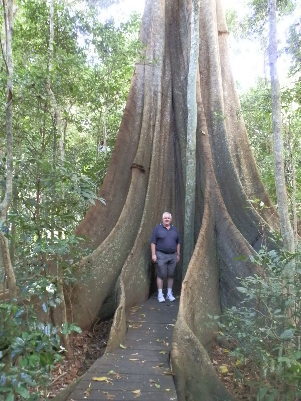
Our first foray was to Mt Basalt Reserve, about 80 km south west of Toowoomba. The local map we had obtained from the caravan park was a bit 'artists impression thereof' so we had a bit of trouble finding it, but eventually we tracked it down. The reserve is only 10 hectares, so the walking trail wasn't particularly long, but we did a fairly sharp climb up each of two rocky peaks, being the remains of ancient volcanic plugs, to get a pleasant view of the surrounding rich Darling Downs farmland.
Apart from the walks we also played in the Easter tournament at the Toowoomba Golf Club, but neither of us did any better than last year. At least it meant we didn't have to stay for presentations!
Thursday, April 5, 2012
Finally Moving on from Coffs Harbour
We've spent the last 2 months at Coffs Harbour making preparations for building our new house. Things have taken a lot longer than we anticipated (those of you who have built before probably won't be surprised) but we are hopeful that things should be able to proceed without us from here, so we're hitting the road again to explore any nooks and crannies of Australia that we may have missed in the last 3 years.
We're going to have to get back into the travelling mindset, as we'd quite settled in at Coffs, joining the golf club, the library and even the local bush walking club. Still, we're looking forward to seeing more of this big country before we settle down again.
Subscribe to:
Posts (Atom)
About Us
- nicholstones
- We set off on the grey nomad adventure on 17 March 2009. This blog shows photos and comments of our adventures.