We're settled in at Albany, on the WA south coast. We intend to stay here until the beginning of March, so we've joined up at the local golf club, who conveniently offer 3 month memberships. We're now playing 3 times a week each - men's day Wednesday, ladies on Thursday, and both of us play on Saturday and Sunday. It's really nice to be part of a club again, and the course is a good test, especially when the wind howls off the bay.
Unfortunately the weather hasn't been very pleasant so far here. Even though temperatures in Perth, 400km north-west, have been hitting 40 degrees, here on the south coast we've been lucky to see half that, with cloudy skies, a cold wind and quite a few showers. Apart from our golf days, the weather has kept us hanging around the van most of the time.
Despite the weather, we had a very pleasant Christmas Day. John rustled up a scrumptious roast lunch with ham, turkey and duck (leftovers will provide sandwiches for a week) followed by fresh raspberries. He also produced a very fancy bottle of chilled champagne for us to toast Christmas and Wendy's birthday.
We wish everyone the compliments of the season, and hope that your Christmas was a joyful one.
Sunday, December 26, 2010
Friday, December 17, 2010
Manjimup Cherry Harmony Festival

 We spent a week at Manjimup in the southern forests area of WA. We were here last year, and we left just before their annual cherry festival, so we decided we would come back this year for the festival weekend. It started on the Friday afternoon, with a golf tournament. John didn't have a very good day, but Wendy managed to hold it together to win second prize - a bag of cherries and a bottle of local wine.
Saturday was the main festival extravaganza, with the highlight being the cherry pip spitting competition. The winner managed to spit a cherry pip over 10 metres, and will be off to NZ next year to represent us in the Australasian titles. Who knew cherry pip spitting was such a serious sport? There were many other festival attractions on Saturday - cooking demonstrations, fashion parade, wood chop competition, timber furniture exhibition, street theatre and heaps of standard festival stalls.

On Sunday we attended the festival long lunch, held in a local cherry orchard. The conditions were perfect, sunny 29 degrees, and the lunch was fantastic. It started around 11:00 with champagne (and cherries) and canapes, and finished not much before 6:00 with a plate of local cheeses. In between there was appetiser, entree, huge main and dessert, each course accompanied with local wine. The attendance was restricted to 200 people, and we had tickets 183 and 184, so we almost missed out!
 For the rest of the week, we played golf a couple more times at Manjimup plus had a game at Bridgetown, 30 km north of Manjimup. We also spent a day exploring Bridgetown, and another day in Nannup, 50km towards Perth. The local Nannup legend says that they still have Tasmanian Tigers, although this is quite unlikely. These towns are all green and leafy, even in this year's drought, and provide a total contrast to the parched wheat belt further north.
Saturday, December 11, 2010
Kojonup - Boyup Brook
 From Narrogin we planned to spend a few days at a town called Katanning. On the way we stopped at Wagin to have a look at the local 'big thing' - the Giant Ram. They left you in no doubt that it was a ram and not a ewe!
We hadn't booked at the caravan park in Narrogin and when we got there we were quite surprised to find that the park was full of workers, which meant they had no room for travellers like us, so we continued on another 40km or so to Kojonup. Both towns are firmly in sheep territory. Kojonup has a very interesting historical display at their visitor centre, we spent several hours exploring both the European and aboriginal stories given. There were a few shocks, such as the praise some footballers gave for their coach in 1972 when he forced the local publican to allow the aboriginal players into the front bar with the rest of the team at the end of year celebration, instead of making them stay out in the back yard. In 1972! It certainly came as an unwelcome surprise to us to realise how close to the surface overt racism has been in Australia so recently.
On another day we headed back to Katanning to investigate what local delights we had been
 denied. It turned out that there weren't very many, but we ended up spending nearly an hour at the local saleyards. This is the largest sheep saleyard in WA, trading more than a million sheep every year. We were there the day before sale day when they were unloading the sheep and it was frantic with sheep, dogs and sweating workers sorting and penning the animals. Apart from barking dogs, the sheep control implement of choice appeared to be a supermarket plastic bag tied to a stick, the sheep bolted from
  this when shaken at them. Or maybe they were just frightened of their shadows, they certainly don't appear to be the brightest of creatures!
Washing day at Kojonup provided a surprise. While John was doing the ironing afterwards he was horrified to find a bee crawl out of the shirt he had been wearing when he had been attacked while we were out walking in Narrogin. It had not only stayed hidden somewhere inside his shirt all that evening, but had somehow survived 3 days in the dirty clothes bag, then a washing machine cycle and all day flapping on the clothes line. It presumably didn't survive being crushed in a paper towel, sealed into a plastic bag and deposited very quickly into the rubbish bin!
From Kojonup we moved a further 90km to Boyup Brook, another sleepy sheep town. While Boyup Brook itself didn't offer a great deal for the adventurous tourist, we took a day trip to the mining town of Greenbushes and did a 10km walk through forest and past evidence of the area's previous mine history - mull heaps, mine shafts, tunnels and lakes formed in old mine workings. The current, still working mine has very little to see, as most of the activity now occurs underground.
Sunday, December 5, 2010
Narrogin
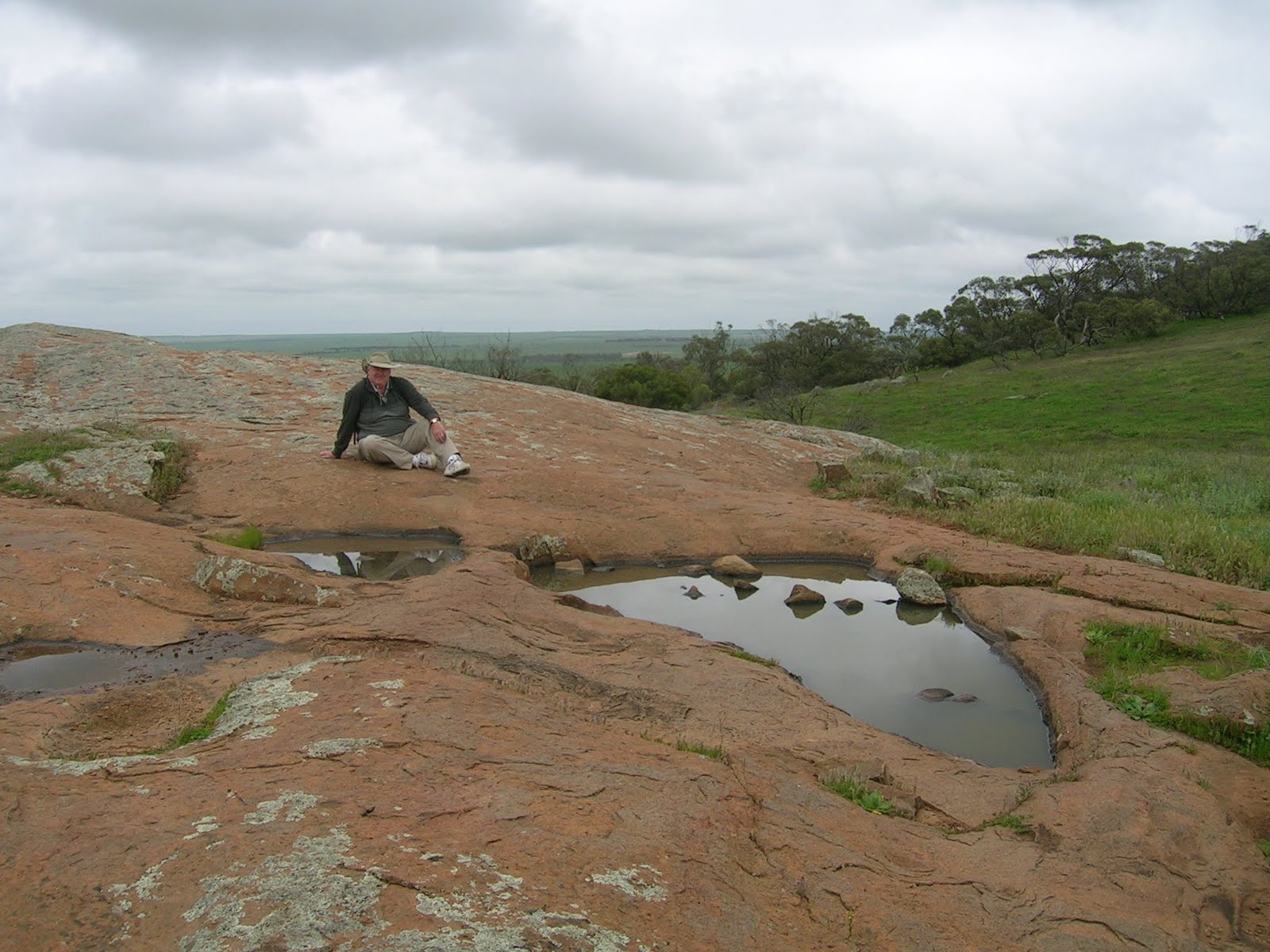
 Narrogin is a town of some 4,500 souls in Western Australia's southern wheatbelt. In common with the rest of southern WA it has endured the driest year on record (in stark contrast to the floods happening in eastern Australia) so the countryside around is brown, dry and dusty. Like much of the rest of wheat country throughout Australia, there are numerous granite outcrops in the area, we spent a leisurely half day driving around nearby townships and climbing various rock outcrops.
Opposite the caravan park in Narrogin itself there is a bush reserve called
 Foxes Lair with several walking trails. Our exploration of this yesterday was abruptly curtailed when John went off trail slightly for a comfort stop and disturbed a swarm of bees, they gave him half a dozen nasty stings before he was able to outrun them. Several of the stings are still red and swollen today, if things don't improve in the next day or two he may have to seek professional medical assistance. Before our walk was interrupted we came across the tree shown in the photo at right - it has doggedly overcome its misfortune at germinating underneath a rock!
The highlight of our visit here has undoubtedly been the nature reserve called Dryandra Woodland, about 30km north of Narrogin. We spent a full day at the woodland, doing multiple walks through the dry scrub, including an interesting walk around the traces of a long gone railway line. We also did over 50km of drive trails, scattered not just with numerous information panels but also radio information stops - places with hidden FM transmitters where you not only get to hear some of the history but also sounds of the bush such as bird and animal noises. A couple of evenings ago we returned to Dryandra to do a night tour at Barna Mia, the animal sanctuary hidden in the heart of the reserve. Here they are breeding small marsupials such as bilbies (of Easter chocolate fame), boodies (burrowing bettongs) and rufous hare-wallabies to enable their release back into the wild in areas where populations have been killed by feral foxes and cats. After watching a video on the history of the sanctuary and animals within, the guide took us out by torchlight to view these nocturnal animals in their natural habitat. He cheats somewhat as he puts out food for them, but it was still fabulous to see these shy (and some not so shy) wild animals scurrying around, squabbling and darting almost under our feet. We were strictly warned not to try and touch them no matter how close they come, as a bite could leave you sick for months, but it is hard to resist trying to stroke the little cuties when they are so close. With only 4 of us on the tour it was a fabulous nature experience, the only downside being that we were unable to take any photographs as the flash could harm their eyes.
 Of course, as always we did the history walk around town, plus here they have a 'centenary pathway', which was laid out to celebrate Narrogin's centenary in 1991. There are 100 stone tiles, each depicting one or more events in the town's history. The one that amazed us was the one representing 1951, when apparently Narrogin hosted the Australian Grand Prix!
Wednesday, December 1, 2010
Bunbury
 Our trip north from Busselton to Bunbury was less than 70 km, so we had a very leisurely start to our travel day. John's shoulder has recovered enough for him to get back on the golf course, so we have had several games on several courses - Sanctuary, Bunbury (we played in a 2-ball ambrose in the Sunday comp), Collie and Binningup. The last is a sensational 9-hole course, apparently it was built during the heady days of WA Inc and intended as a resort course, but things went pear shaped after the first nine holes were built so it was never completed. There is nothing there but the course, an honesty box for green fees and a portable toilet - no club house, ball washers or even a tap. However, the course is magnificent, with superb couch fairways, large, true greens and a long challenging layout. It included the longest ladies' par 5 Wendy has ever played - at 485 metres into the wind with an uphill start it was a mighty tough proposition. If someone ever builds another 9 holes there it will be one of Australia's premier courses.
Other than play golf we haven't done a great deal here. The caravan park is on the shore of an inlet and we walked the 5km circuit pathway. The photo above shows the park from the opposite shore - if you look very, very hard you can actually see the back of our van second left from the camper van. Bunbury is the largest town we will be in for a while so we also did some shopping here for clothes, shoes and some hardware items for the van.
Thursday, November 25, 2010
Australia's South West Corner
We've spent the last 2 weeks in Busselton, in WA's south west. Our timing here revolved around a mixed tournament at the Busselton Golf Club, the Leaney Cup, which was held over the first weekend  we were here. Although we both played reasonably well, we didn't manage to feature in the prize giving.
Having spent some time here last year, we had done most of the major attractions on offer in the area. However, working on the principle that you can never have enough wine, even in a caravan, we spent some time revisiting various wineries in the Margaret River area, stocking up on both still and sparkling wine, and enjoying lunches at several wineries. We also revisited the local chocolate and cheese factories - it would be a sin not to really!
The coast off Busselton is on the whale highway used by whales to migrate between their feeding grounds in Antarctica and their breeding grounds in the tropics. At this time of the year they are heading southwards and we spent half a day on a whale watching cruise. We did one of these a couple of years ago at Coffs Harbour on the east coast, and while at the time we had been reasonably happy with our glimpses of distant whales, this tour provided a much closer experience. One mother and calf not only got close to the boat - they actually swam right underneath it! You could just about reach out and touch them, and the water was so clear that you could easily see the markings and barnacles on their backs. Further out to sea a group of juvenile males were leaping about and having fun, crashing their huge tails into the water and competing to make the biggest splash. Boys will be boys!
Busselton town is on Geographe Bay. At the western end of the bay is Cape Naturaliste, then the west coast stretches for 135 km down to Cape Leeuwin, where the Southern Ocean meets the Indian Ocean. The Cape to Cape walking trail has been constructed between the two. We certainly didn't do the entire stretch, but Wendy spent several hours walking the first 14 km section. For the most part it was very enjoyable, with terrific views of the coastline cliffs, sandy beaches and surf. The little critters in the photo at right littered the waters edge on one beach, we're still not quite sure what they are. John decided not to do the walk, but provided car ferry services.
The coastline between the two capes is a long stretch of limestone pitted with numerous caves. Last year we visited two of the caves that are open to the public, this year we went to another. Lake Cave actually has a stream running through it rather than a lake as the name suggests. It is much smaller than it used to be, apparently about 700 years ago a large part of the cave roof collapsed - they can tell when this
  happened by the size of the trees that have grown up in the resulting sink hole. There are 300 steps down to the base of the cave (and 300 steps back up again) but it is a pretty walk down through the leafy green to the rubble at the bottom. The exposed stalactites are no longer pristine white but covered in dust, lichen and spider webs. Inside the cave itself the most striking feature is a suspended upside-down 'table' that hangs above the water. This was apparently formed when a change in the stream flow caused the sand that was underneath the formation to erode away. The estimated weight of the formation is 5.5 tonne, so the stalactites holding it up must have a very firm grip on the ceiling!
As well as the Leaney Cup, the two of us also played in the Busselton Golf Club's competition days, plus we had a hit at Margaret River. Unfortunately, John's shoulder has been giving him increasing trouble, and he got to the point during our stay here that he could barely lift his arm, let alone swing a golf club. He's now been given a cortisone injection into the affected area and we are hopeful that he will shortly be back on the greens.
 we were here. Although we both played reasonably well, we didn't manage to feature in the prize giving.
Having spent some time here last year, we had done most of the major attractions on offer in the area. However, working on the principle that you can never have enough wine, even in a caravan, we spent some time revisiting various wineries in the Margaret River area, stocking up on both still and sparkling wine, and enjoying lunches at several wineries. We also revisited the local chocolate and cheese factories - it would be a sin not to really!
The coast off Busselton is on the whale highway used by whales to migrate between their feeding grounds in Antarctica and their breeding grounds in the tropics. At this time of the year they are heading southwards and we spent half a day on a whale watching cruise. We did one of these a couple of years ago at Coffs Harbour on the east coast, and while at the time we had been reasonably happy with our glimpses of distant whales, this tour provided a much closer experience. One mother and calf not only got close to the boat - they actually swam right underneath it! You could just about reach out and touch them, and the water was so clear that you could easily see the markings and barnacles on their backs. Further out to sea a group of juvenile males were leaping about and having fun, crashing their huge tails into the water and
 competing to make the biggest splash. Boys will be boys!
Busselton town is on Geographe Bay. At the western end of the bay is Cape Naturaliste, then the west coast stretches for 135 km down to Cape Leeuwin, where the Southern Ocean meets the Indian Ocean. The Cape to Cape walking trail has been constructed between the two. We certainly didn't do the entire stretch, but Wendy spent several hours walking the first 14 km section. For the most part it was very enjoyable, with terrific views of the coastline cliffs, sandy beaches and surf. The little critters in the photo at right littered the waters edge on one beach, we're still not quite sure what they are. John decided not to do the walk, but provided car ferry services.
The coastline between the two capes is a long stretch of
 limestone pitted with numerous caves. Last year we visited two of the caves that are open to the public, this year we went to another. Lake Cave actually has a stream running through it rather than a lake as the name suggests. It is much smaller than it used to be, apparently about 700 years ago a large part of the cave roof collapsed - they can tell when this
  happened by the size of the trees that have grown up in the resulting sink hole. There are 300 steps down to the base of the cave (and 300 steps back up again) but it is a pretty walk down through the leafy green to the rubble at the bottom. The exposed stalactites are no longer pristine white but covered in dust, lichen and spider webs. Inside the cave itself the most striking feature is a suspended upside-down 'table' that hangs above the water. This was apparently formed when a change in the stream flow caused the sand that was underneath the formation to erode away. The estimated weight of the formation is 5.5 tonne, so the stalactites holding it up must have a very firm grip on the ceiling!
As well as the Leaney Cup, the two of us also played in the Busselton Golf Club's competition days, plus we had a hit at Margaret River. Unfortunately, John's shoulder has been giving him increasing trouble, and he got to the point during our stay here that he could barely lift his arm, let alone swing a golf club. He's now been given a cortisone injection into the affected area and we are hopeful that he will shortly be back on the greens.
Thursday, November 11, 2010
Still in Perth
 We've done quite a bit of exploring of Perth in the last week. King's Park is a wonderful area over 1000 acres in size, walking distance from the city centre (as shown in the photo on the left). It is a terrific reflection on successive city councils that the park has remained intact, I'm not sure that other governments would have resisted the temptation to nibble bits off here and there for housing and other development. We spent half a day walking various trails, admiring numerous memorials, fountains and
  gardens, and being stunned by the spectacular views across the Perth city and suburbs and out to the far hills and sea.
On another day we caught the train into town and did a boat cruise down the Swan River to Fremantle. The trip included a circuit on the tourist tram around the historic port city, then lunch on the boat back up river. It was very enjoyable and compared well with the other boat cruises we have done on this trip. While at the Fremantle jetty waiting for the boat

for the return trip, we were quite taken by the series of whimsical sculptures depicting various aspects of Perth and Fremantle life. At first glance the one pictured here is just a cute diver, but the title of 'Bottom of the Harbour' and description of it being a businessman taking his briefcase for swim would bring a wry smile to the face of any Australian who remembers the tax avoidance scandals of the 1970s.
We also visited several more wineries here in the Swan Valley in the last week, as well as the local ice creamery. It hasn't all been fun though, we spent a morning washing down the outside of the van, the first time it had been done since we were in Port Lincoln 8 months ago. Hard work, but the white bodywork gleaming in the sun gave us quite some satisfaction.
Of course, the main thing we've done here in Perth is play on some of the fabulous golf courses in the area. For those interested. in our 17 days here we have played The Vines (both courses), Rockingham, Mt Lawley, Hillview (both courses), Kennedy Bay and Lakelands.
Wednesday, November 3, 2010
Swan Valley, Perth
 We're currently staying in the Swan Valley, in the northern suburbs of Perth. Last year in Perth we stayed at Rockingham which is well south of the city, so we thought we'd check out the other side of town this time. We're planning to stay here for nearly 3 weeks and to spend a lot of days playing golf, but we are also doing some tourist things.
The Swan Valley is renowned for food and wine, we've visited a couple of wineries so far with more planned. We've also checked out a couple of breweries and of course the local chocolate shop.
The town of Guildford is at the southern end of the Swan Valley, and is of such heritage value that the entire town is classified by the National Trust. We've done the heritage walking trails around town, and were suitably impressed by the gorgeous old houses and civic buildings and the magnificent plane trees.
For a change of pace, we visited the Gravity Discovery Centre about 40km further north. This
 is attached to the brand new Australian International Gravitation Observatory, a high tech facility that is part of a worldwide project to try and measure gravity waves, which have been hypothesised but never actually observed or proved. The Discovery Centre had all sorts of weird and wonderful displays, plus an outdoor scale model walking track of the solar system. Poor old Pluto has been removed after its demotion from planet status a few years ago.
When we were in Kalgoorlie last year we visited the Charlotte reservoir, where water piped over 500km from Perth
 is stored. This week we visited Mundaring Weir, where the water originates. There was a very interesting display in the original No 1 pump house at the weir covering not just the physical design and construction of the weir and pipeline, but the political shenanigans as well. There was so much public criticism and ridicule of the grand scheme that the chief engineer, the now universally admired C. Y. O'Connor, committed suicide only a few months before the opening of the pipeline. We spent a lot longer here than we had expected, and found it very interesting. It makes you wonder what government in Australia would attempt such a challenge these days, they are much too risk averse to tackle such huge nation building schemes.
Unlike the cold and wet south east of Australia, Perth is still in the grip of drought, and Summer has well and truly started. To escape today's 37 degree heat we went to an air conditioned cinema for the morning screening of 'Let Me In', a so-so horror flick. We had the cinema entirely to ourselves, so maybe everyone else had seen some poor reviews that we hadn't. We had a fun time, it was just like having our very own giant home theatre!
Monday, October 25, 2010
Geraldton Revisited
 We spent a week at Geraldton, and experienced much better weather than we did last year here (see blog post here). Blue skies and sunshine almost every day, but several days of incredibly strong winds would have kept any visiting wind surfers happy. Unfortunately the days of the strongest winds also corresponded to the ones when we played golf, but the 2 courses in town are good enough quality that we enjoyed the games anyway.
While in Geraldton we did several local tours run by volunteer guides. Firstly we went to the St Francis Xavier Cathedral, the magnificent Catholic cathedral designed by priest-architect Monsignor John Hawes. Having learnt all about the priest's life when we were at Mullewa
 recently, we were interested to see his most famous creation, and it didn't disappoint. We also did a tour of the HMAS Sydney memorial, which commemorates the sinking of this ship in WWII by the German ship the Kormoran with the loss of all hands. We visited this memorial the last time we were in Geraldton, but were given a much more intimate insight into the design of the memorial and the incident it commemorates by a very interesting volunteer guide.
We also went to the local meteorological office to see the launch of the daily weather balloon. We had been to the met office in Ceduna a month ago, but decided that, as the tour is free, you can't have too much weather. We were glad we did - in Ceduna there were a couple of dozen grey nomads on the tour which was run by a very jaded old hand on the
 brink of retirement, but here at Geraldton we were the only ones and the weather guru was fresh faced and enthusiastic. He showed us all the high- and low-tech equipment, then filled the balloon with hydrogen and sent it on its way up to the stratosphere.
Just for a change of pace, we headed back to the Chapman Valley winery in the Chapman Valley just north of Geraldton, for a lovely long lunch and to refill the supplies with some nice wine.
Friday, October 22, 2010
Trouble Comes in Threes
With only a fairly short trip from Kalbarri to Geraldton, we had booked the van in for a service at Geraldton for the day we arrived. We figured if we got going early we could be there around 10:00, which would give them plenty of time to do a service and still have us on our site around mid-afternoon. The service timing was also convenient given the tear to the awning experienced at Kalbarri, we figured they could also try and repair that at the same time.
We were up and away bright and early and well on track for a 10am arrival when BANG all of a sudden the car started wobbling over the road. We pulled over and checked out the situation - one of the rear tyres on the car had blown out. We still don't know why, we hadn't seen anything on the road so maybe it had been weakened previously or we ran over a nail or something. It was only a narrow road verge and not very level, but we were fearful of damaging the wheel rim if we tried to go on to somewhere more suitable. It took us a while of crawling around in the dirt trying to get the jack underneath the car before we twigged that step 1 should have been to unhitch the van, things became slightly easier after that (but only slightly). Heaven knows how long it would have taken us to get the wheel changed but a knight in shining armour (or at least an ex-tyrefitter on his way to a day at the beach) stopped and helped out. Even with his strength and knowhow it still delayed us about an hour - and ruined John's shorts - but the caravan service people weren't worried and promised to be done by 4:00.
The first thing we did after dropping off the van was go to the local tyre dealership, where we were solemnly informed that the tyre was stuffed and we would have to buy a new one, they didn't have one the same as the other tyres so we will have to leave the old spare on the car and the new tyre has become the spare. At least they put the new spare back onto the frame on the car for us.
When we returned to pick up the van sure enough it was ready - but still with the tear in the awning. They said that it couldn't be repaired but had to be replaced, in fact they pointed out that it wasn't just the canvas but the frame itself had been damaged. However they were very helpful and assisted us to put in a claim to our insurance company. Today we had to hitch up and take the van over there and they spent the morning installing an entire new awning, frame, canvas - the lot. We had to pay the standard $200 excess, which was less than 10% what it would have cost without the insurance, and we now have a nice new bright awning. We hadn't realised how faded the old one had got!
While we were waiting for the insurance claim to be approved during the week, we started to have trouble with our PC. It has actually been playing up for some months, every now and then it will suddenly shut down for no apparent reason. We had taken it to a PC shop when we were in Yamba but they couldn't find anything wrong with it, and bizarrely it had seemed to be alright since then so we figured they had managed to fix it without even realising it. However, this week it started to happen again, and again and again. The last couple of times we noticed that just before it shut down the battery warning message came up, even though it was plugged into power at the time. We found the local PC shop and they confirmed that indeed our battery is stuffed. They didn't have a replacement of the same type, so now we have the battery removed from the laptop and we are running on mains power only. We'll hopefully be able to get a new battery when we get to Perth next week
So it's been an eventful, and fairly expensive, couple of weeks. Hopefully now that we've had 3 failures so quickly we'll be right again for a while!
Sunday, October 17, 2010
Blown Away at Kalbarri

 Kalbarri is a tourist resort at the mouth of the Murchison River. We spent a few days here last year (see the blog report here), but there is a lot to see and do so we decided to stay for a week this time around. The town is surrounded by the Kalbarri National Park, and although we did all the walks on offer last year we decided the park was worth a repeat visit. The signature rock formation is Nature's Window, and even though we already had several photos from our last visit when another tourist offered to take one with us both in it we
  couldn't resist. Once again we did most of the walks here, although this time we didn't do the 8km one, just the shorter ones. As well as having spectacular gorges, the national park has a section that runs along the coast with high sandstone cliffs. For some reason the Indian Ocean seems to be much bluer than the Pacific Ocean and the clear waters of the national park are gorgeous. The local wildlife obviously like it, we saw a pod of dolphins catching waves right near town, surfing almost into the beach. They have an unfair advantage over human surfers, when they run out of wave they just duck underneath and swim underwater back out to the start of the break, they don't have to struggle back through the breakers.
As well as the natural attractions, we decided to take advantage of some
 of the tourist activities on offer here. Not to be faint hearted about it, we signed up for a 3 hour quad bike adventure. It started with a 1 minute safety briefing, then we spent 10 minutes getting used to the feel of the
  bikes and how to use the controls. After that we were off, along sandy tracks, stony hills, washouts, rutted trails and rocky ledges. The bikes don't have power steering so you have to wrestle them around corners and through the ruts, holes and rocks. The accelerator is a thumb press which is very hard to control while the bike is bumping around. However, we had a total ball, and despite the ache in our arms and hands the next day we absolutely loved it.
Our other activities here couldn't compare for excitement, but were nevertheless enjoyable. We spent an hour or so walking through a parrot
 breeding centre, admiring the multicoloured birds as they screeched and twittered. We also saw some birds of a different feather at the daily pelican feeding sessions run down by the river. And of course we had a couple of games of golf at the local course, including participating in the Friday afternoon 9-hole competition, where we happened to play with the local lady who had run the pelican feeding session we attended. She also does the sporting announcements for Kalbarri on ABC radio on Saturday morning, when we tuned in while we were having breakfast we heard her send us a special cheerio.
The only downside at Kalbarri is the incessant wind. In the middle of our stay it was so strong that the corner of our canvas awning ripped, so now we can't put the awning up until we can get it repaired, hopefully at our next stop at Geraldton.
Monday, October 11, 2010
Wheatfields and Wildflowers


 We've spent a few days meandering through the northern Western Australian wheatbelt, which is also wildflower country. We have to confess that this was partly to avoid the coast while the local school holidays were on, but we also found lots to see and do.
We spent 3 nights at Perenjori and 1 at Mullewa. The most famous local flower is the wreath flower, and we were lucky enough to see some magnificent specimens. Unlike the eastern states,
 WA is still in the grip of drought, and 2010 has been one of the driest years on record, so it apparently hasn't been a great wildflower season, but we still found plenty of colour to be impressed by.
This region is also famous for priest-architect Monsignor John Hawes, and we visited several of
 the churches he designed and built here. Mullewa was his parish for 22 years, and he not only designed the church pictured at left, but provided most of the labour to build it and painted several of the pictures that decorate the interior. Mullewa has multiple walks with excellent information panels, one of them gave us a terrific insight into the life and works of Monsignor Hawes, while others covered Mullewa's railway heritage, the town's history and the bushland and wildflowers of the region. Needless to say, we did all the walks on offer, even though the flies were far more friendly than we would like, and the wind has approached gale force.
Being Western Australia, you can't go far without stumbling over a mine of some sort, and there
 are some new ones being developed just east of Perenjori. We first experienced this on our way there, when we spent 80km and well over an hour stuck behind some piece of huge equipment being trucked to the new mine - the up side was that we knew that we wouldn't have any traffic coming towards us, as anything coming the other way had to almost bury itself in the scrub beside the
  road to let the oversize load past. From Perenjori we did a heritage drive to the old gold mining township of Rothsay, the drive was supposed to be a loop but part of the road was closed due to a new mine being set up (the destination of the aforementioned oversize load), so we decided to take a different route back to town. We were half way along our chosen back road when we unexpectedly came across a sign saying 'Security checkpoint ahead' and found ourselves being interrogated by a security guard. It turned out the the previously public back road had the previous week been privatised and given to a new mine company, and if we wanted to proceed on our chosen route we would need to be escorted through the new mine development. We initially said we would return the way we came, but it was close to lunch time so we told the guard we would pull off into the scrub on the side of the road and eat the sandwiches we had brought with us. By the time we finished lunch the mine security escort had
  turned up, so we decided to continue on our original planned route after all, which meant we followed our escort car for the next 10km or so, with check in points every few km. We felt like royalty with our own dedicated escort vehicle clearing the way for us! By this stage we were off the edge of the only map we had, but John's excellent navigation skills got us back on track to our home base.
We have finally shown the benefit of experience, stocking up at the local small supermarket in Perenjori well before it closed at lunch time on Saturday, with virtually no shopping available here in outback WA until Monday morning.
Wednesday, October 6, 2010
Merredin
 Merredin is in the heart of the WA wheat belt, less than 300km east of Perth, and is larger than it appears at first glance. We found quite a bit to do in the town and surrounding areas and spent 3 nights here.
The town was founded as a stopping place on the way to the goldfields, and when the railway reached it in 1893 its importance was assured. Merredin Peak, the local granite rock formation, allowed water to be captured for use by the steam locomotives, and the town developed as a major hub for the storage and transport of the abundant grain grown in the region. We of course did the heritage trail around the peak and climbed to the top for good views over the town and pastoral lands. We also explored the remains of the military hospital that briefly occupied the land below the peak during WW II, established far enough from the coast so that enemy planes couldn't reach it without refueling. As the war progressed and it became obvious that there
 wouldn't be an invasion this far south the hospital was packed up and moved to New Guinea, leaving only concrete foundations in the scrub. The trail around the site gave lots of interesting information and reproduced photos of the hospital during its bustling peak.
One thing offered here that we hadn't seen in other small towns was a local town bus tour. This was a surprisingly interesting 1.5 hours, run by a man who was obviously passionate about his home
 town. It gave a good insight into not just Merredin's past but its expected future, and the work being done by the local council to diversify the town's economic base. The tour included an inside look at the massive silos where grain is stored before being loaded onto trains and sent off to Fremantle for shipping overseas. With the 2010 harvest only a few weeks away the silos are almost empty now, and felt like massive echoing caverns.
Rounding off our time here we spent half a day exploring further south of Merredin, including yet another granite outcrop of Totadgin Rock, a sculpture park at Bruce Rock and a good lookout and heritage walk at Narembeen.
Sunday, October 3, 2010
Catching our Breath in Kalgoorlie
 We've spent a couple of days in Kalgoorlie catching our breath after dashing across the Nullarbor, and basking in the lovely warm sunshine. We spent a while here when we were in WA earlier in the trip (almost exactly a year ago in fact) so there wasn't too much in the way of tourist delights that we hadn't already done. However, we spent half a day at the local museum, then John watched the AFL grand final replay.
This morning (Sunday) we had noticed was the local monthly market, but this proved less than exciting - barely half a dozen rather tatty stalls, plus a fairly ordinary sausage sizzle. The highlight of our stay here was a game at the brand new Kalgoorlie Golf Club, a green oasis with lovely grassed fairways and greens, and red dirt outside of these narrow boundaries. The only drawback with the course is that it has obviously been built as a cart course, so it was quite a long walk - not the least being almost a full kilometre between the 9th green and the 10th tee.
Today is our wedding anniversary, so although Sunday evening in Kalgoorlie provides limited dining options we had a celebration dinner out. Back to standard caravan fare tomorrow.
Friday, October 1, 2010
Whales Across the Nullarbor

 We spent 3 days travelling across the Nullarbor Plains from Ceduna to Kalgoorlie. The wet season experienced by southern Australia was starkly evident, with the landscape being more green than brown, and covered with grasses and groundcover plants, instead of just scrubby bush and dirt. In fact it rained for the final 500km of the journey, which made it rather tiring.
The highlight of travelling across the Nullarbor at this time of year is the Head of Bight whale watching area. Southern right whales visit the Great Australian Bight during winter and early Spring, to give birth and rest up away from the cold Antarctic waters. The Head of Bight is the northernmost point of the Great Australian Bight, and provides viewing platforms down to the sheltered waters favoured by the whales and along the spectacular cliff formations that plunge down into the waters of the Bight. Although the whale photo at the top doesn't look like much, we were more than satisfied with our close up experience with these massive mammals, as the whale and her calf pictured cruised slowly along the cliff line right below where we were standing. In fact, there at least half a dozen whales within easy spotting distance, some of them sporting playfully in the waves only a couple of hundred metres offshore.
Its been a fairly tiring 3 days travelling, although gaining 1.5 hours due to the time change has meant we haven't arrived at our destination too late each day. We usually spend travel time chatting quietly or just looking at the scenery, but we decided to turn the last 2 long days into our own private music festival, and have been taking it in turns to pick the next cd to play. Needless to say John's choices tended more towards the headbanging than Wendy's quieter selections!
Tuesday, September 28, 2010
Ceduna
 Although nearly 500km east of the Western Australia border, Ceduna is the last decent sized town in South Australia heading west. Although it doesn't have a lot of tourist delights, we spent a couple of days here before heading across the Nullarbor back to WA. The highlight was a visit to the local meteorological office for the daily launch of the weather balloon. Filled with hydrogen, this explodes out of its little store house an
 d rises like a bat out of hell into the air. Apparently it keeps going to about 60,000 feet and stretches to the size of a small room before finally bursting. The met radar keeps track of it all the way, so that punters like us can know what to wear tomorrow. The local meteorologist gave a moderately interesting talk about how the met station works and what his duties are (not much it seems, mostly just making sure the computers that are doing all the work are still going) and we had a look at the other bits and pieces of equipment at the station, ranging from thermometers stuck in the ground, to a rainwater gauge and the evaporation level monitor shown in the photo at right. Some of it mind-blowingly high-tech and others not much more sophisticated than a wet finger stuck in the air!
The other main thing we did here at Ceduna was a visit to the local aboriginal cultural centre where we actually bought a painting. Our relationship to 'culcha' is usually fairly distant, so this was bigger deal for us than perhaps you might assume. Now we just have to keep it undamaged in the van until we once again have a wall to hang it on.
One good thing about Ceduna is the local seafood outlet, we've had meals of fish, prawns and bugs, all local and freshly caught, and John managed to scoff a dozen freshly opened oysters for morning tea.
Saturday, September 25, 2010
Wudinna
 Wudinna is only 100 km west of Kimba, making it our shortest travel day so far on the trip. This meant that although we only spent 2 nights here, we effectively had almost 2 full days to take in all the sights in the area. Wudinna is in the heart of 'Granite Country', and there are numerous rock outcrops to explore. A scramble to the top of several them rewarded us with panoramic views over the wheat fields of the Eyre Peninsula. The green countryside belies how dry this area really is. Most of the granite outcrops have elaborate rainwater catchment systems, with small walls
  circling the base of each rock directing any rain that falls into small dams. Most of the systems have fallen into disrepair now that water is piped in to the district, which is a bit sad.
On our second day here we spent the day at the Gawler Ranges National Park, about 50km to the north. While the park has no formal walking trails, we had an enjoyable time exploring the various rock formations and abandoned pastoral buildings. As you can see from the photo at left, they even managed to stretch to a waterfall! The Gawler Ranges are supposedly one of the oldest landscapes on earth and are volcanic in origin, resulting in
 interesting 'organ pipe' type formations scattered throughout the park, including behind John in this photo. The park itself is fairly undeveloped, and the trails to several of the features gave us some pretty rugged 4wd experiences.
We got back from the Gawler Ranges in time for John to watch the last quarter of the tied AFL Grand Final game, providing more excitement than we've had from any of the natural wonders here!
Thursday, September 23, 2010
Port Augusta - Kimba

 We spent a day playing golf in Port Augusta, having spent several days here earlier in the trip there wasn't much in the way of tourist delights that we hadn't already done. We then moved on to Kimba, which is in the north of the Eyre Peninsula, and
  claims to be half way across Australia. Given we were on almost the most easterly point of the continent not much more than a week ago that's quite a bit of travelling we've done fairly quickly.
Kimba services a large grain growing district and is dominated by grain
 silos. Apart from a visit to the Big Galah, where Wendy bought a couple of pairs of ear-rings as a memento, we found enough to occupy ourselves here for a couple of days. We did quite a bit of walking, firstly on the local town history walk, then to Moseley Nobs, an interesting 3km trail around a series of hummocks providing sweeping views down the Eyre Peninsula, and then 6km through a nature reserve on the edge of town to a good lookout.
On the second day here we drove through the wheat and canola fields of the central Eyre Peninsula. We first visited Carappee Hill, which is the highest point on the Peninsula and the second largest monolith in South Australia. With no marked
 walking trails we scrambled partway up in the drizzle, but didn't scale the full height. Several lookouts on various local hills and peaks (including the cutely named Ticklebelly Hill), plus an excellent pub lunch in the town of Cleve rounded off a pleasant and scenic day.
Subscribe to:
Posts (Atom)
About Us

- nicholstones
- We set off on the grey nomad adventure on 17 March 2009. This blog shows photos and comments of our adventures.
Itinerary for Mail
