The trials and tribulations of Wendy and John on their Grey Nomad adventure around Australia.

Wednesday, December 28, 2011

Christmas in Armidale

One of the problems with living in the caravan is finding somewhere to spend school holidays. Anywhere on the coast tends to be a family holiday destination, and not only escalates in price but fills up with kids. This year we've decided to spend the Christmas period in Armidale, on the New England Tablelands in central NSW. Like most of the east coast, the summer is struggling to get started in Armidale. Most days we've been here have been fairly cool - we've even got out the winter doona again.


The first day we were here we did the half day heritage bus tour, provided free from the visitor information centre. Armidale has a lot of lovely old buildings, with lots of verandahs and iron lace work. After the bus tour we did the heritage walk around town, getting a closer up view of the architecture.


On another day we drove 200km northwards to Tenterfield, made famous in the Peter Allen song 'Tenterfield Saddler'. The saddler's building is still there, with no resident saddler but still selling leather goods. Apart from the local heritage walk we also did an interesting drive around various granite outcrops and to the local lookout.

Not yet sated with local heritage, we did a scenic drive down to Uralla, about 20km south, where we once again did the heritage walk around town. The New England area is all Captain Thunderbolt country, and there are numerous sites scattered throughout the tablelands supposedly used by the 1860s bushranger. Captain Thunderbolt was shot and killed just near Uralla, and they are as proud of him as if he had discovered a cure for cancer.


Christmas Day was cool and cloudy, ideal weather to indulge in a Christmas dinner of duck and ham with roasted veg, along with some delicious sparkling. Once again John excelled himself, with Wendy taking advantage of it being her birthday to relax and be indulged.

Monday, December 19, 2011

Coffs Harbour

We've had 3 weeks at Coffs Harbour, on the NSW mid-north coast. We spent 5 weeks here a little over 3 years ago, when we did our 3 month 'shake-down' trip of the caravan, and at that time we did most of the tourist sights in the area (the most famous of which is the 'Big Banana'). So we've spent most of our time here this time relaxing, playing golf and contemplating our future. After almost 3 years on the road we feel we've covered most of Australia, and we're getting close to being ready to settle down again. With reportedly just about the best temperate climate in the world Coffs is an attractive place to make a home base, and we have decided to take the plunge, purchasing a block of land here. Now all we have to do is engage a builder, design a house and have it built - simple really! Luckily we don't have to actually be present for most of this process, so we will still spend most of 2012 travelling, but hope to be in our new house by Christmas next year. Exciting times!

Wednesday, November 30, 2011

Gone From Queensland

After 3 months making our way slowly down the Queensland coast, we've finished in Queensland and headed south to NSW. We covered nearly 2,000 kilometres from the northern tropics to the state's south east, staying at or near most major population centres and experiencing most of the tourist delights on offer. The best known attraction of the northern Queensland coast is of course the Great Barrier Reef, the only living thing that can be seen from space. We visited Green Island and Magnetic Island and went snorkelling at the Low Isles near Port Douglas, we could have visited any number of other islands and had lots of other boat, snorkelling or diving trips, but we figured that after a while all coral starts to look the same.

We did quite a bit of walking at various national parks, although not much of it was wildly memorable - it seems that the western parts of this country offer much more spectacular experiences. Still, various waterfalls, gorges and coastal views have kept us sufficiently interested.

The countryside is remarkably similar all down the coast. Sugar cane fields stretch from north of Cairns down to Bundaberg, and the ubiquitous Australian scrub fills up many of the spaces in between. You can tell the local rainfall level by the colour of the landscape, vibrant green around Cairns and Tully, a lot browner around Townsville.

One thing that sets the Queensland coast apart from the west coast of Australia is the number of large towns, even cities. Our longest journey between stops was less than 400km, several times we had not much more than 100km, or even less, between places to stay. And in between the places we chose to stay at there were always innumerable villages and towns. Contrast this with the northern half of Western Australia, where you can do journeys of 700km without passing through a single settlement!

Having got as far south as Bundaberg we decided we really couldn't face the huge conurbation that is the Sunshine Coast/Brisbane/Gold Coast megalopolis, so travelled for 2 days down to Coffs Harbour, on the NSW mid-north coast. We'll now sit back for a few weeks and think about where our journey will take us next year.

Sunday, November 27, 2011

Bundaberg

Still in the Queensland sugar cane belt, Bundaberg is famous for its rum. You can't visit here without doing a tour of the rum distillery, which culminates in a free tasting. We did the tour at 10:00, and neither of us is very keen on rum, so we actually declined the tasting, although we did taste some molasses, which is rum's raw ingredient. Unfortunately one of the rules of the tour is that, due to the heady alcoholic fumed atmosphere, you can't take any electronic devices - cameras, watches, mobile phones all have to be lodged in a locker before you can enter the distillery. This means we don't have any photos of the distillation process, we have to be content with the 'Big Rum Bottle'!

Bundaberg also has a thriving ginger industry, and we visited the local ginger beer brewery. As well as naturally brewed ginger beer, they produce a range of other brewed soft drinks such as sarsaparilla and lemon, lime and bitters. Part of the tour (only a display in the visitor centre, unfortunately, not the actual factory floor) included a tasting of all their products, we left feeling rather bloated after all that soft drink. We also visited the local cooperage, where barrels are made for Bundy rum. Their main product is small kegs for use in the home, they were hard at it for the Christmas trade. We tried our hand at putting together a keg from pre-cut staves, it was like a jigsaw with numbers instead of a picture, we're not sure that our finished product would actually have been water (or wine) tight.

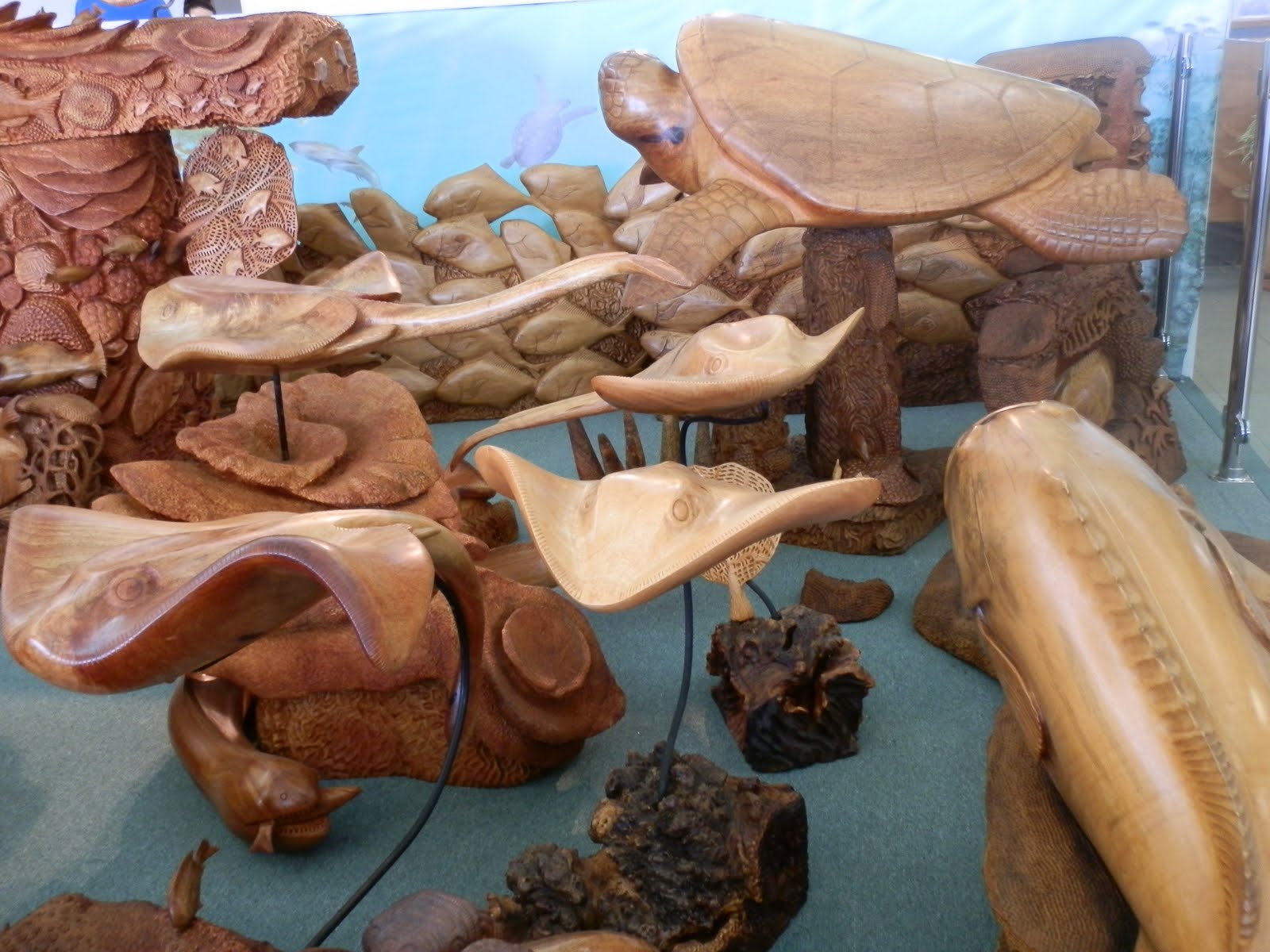
Bundaberg doesn't provide much in the way of local bush walking, but we did visit Sharon Gorge for a short walk (and an encounter with a rather large monitor) and the Mystery Craters, a bunch of holes-in-the-ground that, apparently, defy scientific explanation. We also visited Denizens of the Deep, a huge wood carving at the local council office, showing all things reef related.

We happened to be visiting Bundaberg in the middle of the season for the latest production of the local amateur theatre group. One of the things we miss about living on the road is live theatre, so we went along on Friday night. Apart from a few fluffed lines, they put on a terrific production, and we really enjoyed our theatrical experience.

The Mon Repos beach near Bundaberg is noted for turtles visiting to lay their eggs. The egg laying season only started recently, hatching doesn't start until January. We booked in for the 'Turtle Experience' with some trepidation, the 'experience' relies on whether or not turtles choose to visit the beach and lay their eggs that night. At the beginning of the night you get allocated to a group in the order in which you booked the 'experience'. Each group has around 50 people, and despite having booked almost a week earlier we were in Group 2. The local radio has a 'turtle report' each morning and we'd paid close attention with some trepidation - it appeared that the turtles frequently didn't visit until close to midnight. However, we turned out to be really lucky, Group 1 was called around 7:30, and Group 2 only about 10 minutes later. We all listened attentively to our instructions (keep together, no lights, don't approach the turtle until instructed) then moved en masse down to the beach. 'Our' turtle was a bit nervous, she tried 3 different nest sites before finally settling down to dig her nest and lay her eggs. Meanwhile Group 2 milled around in the dark on the beach, watching the night sky for shooting stars. Finally, a good hour or more after we had been called, we got to see 'our turtle'. At this stage she was still digging her nest, flicking the sand away with her hind flippers. We had to make sure we stayed out of her eye-line, to avoid spooking her, which meant that only about 1 quarter of the group could actually see anything at any one time. We rotated around as the turtle dug, flipped sand, dug, flipped sand..... Her hearing is at a different pitch to the human voice, so the ranger assigned to our group was able to speak in a normal tone explaining what was happening. Finally the nest was dug to her satisfaction and she started to lay her eggs. The rangers picked out some of the eggs from the nest and showed us - they were almost the exact size and appearance of table tennis balls, with a gooey coating. After she'd laid about 20 eggs, the ranger considered her to be committed to the operation, and we were allowed to spread out and watch her from all sides. Once she had laid all her eggs for the night and started to cover over the nest, we were allowed to take photos. The rangers also checked her health, measured her and recorded her vital details. The poor turtle suffered all the affronts to her dignity with aplomb, finally finishing her nesting and lumbering back to sea to cook up the next batch of eggs for laying in a few weeks.

The whole experience took over 2 hours, and ended up being even more interesting than we had hoped. 'Our' turtles hatchlings should emerge some time in January, hopefully they will all make it down the beach to the ocean, to return in about 30 years to start the cycle all over again. Returning back past the visitor centre to the car park afterward around 10:00 pm, we were glad we'd booked early - the people in group 4 were still waiting for 'their' turtle to emerge from the waves!

Saturday, November 19, 2011

Agnes Water

Agnes Water and the adjacent township of Town of 1770 are beach holiday destinations, trading on their position as the most northerly surf beach in Queensland and the southern extent of the Great Barrier Reef. Our caravan park had absolute beach frontage, and although we aren't usually much into swimming we decided to take advantage of this position to have a dip before breakfast a couple of mornings. The water was surprisingly mild, even Wendy, who usually struggles to get her head under water, needed little encouragement to dive under the waves.

The unusually named Town of 1770 marks the site of the second landfall Captain Cook made in his journey of discovery up the Australian east coast. A cairn marks the spot where Cook landed, along a walk around a headland which protects Bustard Bay where the Endeavour anchored. We also hiked up a short steep track in Eurimbula National Park to a lookout back to the same headland.

Apart from a short 9 hole golf course, there wasn't much else to occupy us here at Agnes Water. However, with the Presidents Cup golf tournament on television every day, we have to admit that we spent a great deal of our few days here inside the van glued to the screen. If only those professionals played a bit faster we might have had more time to get out and walk along the beach!

Wednesday, November 16, 2011

Yeppoon

Yeppoon is a popular holiday town on the coast about 30km from Rockhampton. Like other seaside resorts we have stopped at recently the attraction is based around the beach and the offshore islands, with not a lot else on offer. Luckily for us, there are several good golf courses, we have played 4 games in our week here, including one at Rockhampton.

Its not all been golf though, we did a couple of short walks at the Byfield and Capricorn Coast National Parks, and did a scenic drive along the coast and in to Rockhampton. The picture at left is of a sculpture at the small township of Emu Park, commemorating Captain James Cook's visit to Australia's east coast in 1770. The ship 'sings' in the wind, the day we visited there was only a light breeze but the hidden pipes produced a lovely light musical sound. The photo at right shows the remarkable eroded remains of a volcanic plug from 75 million years ago, when this whole area was a volcanic hot spot.

Rockhampton and Yeppoon sit just north of the Tropic of Capricorn, so once we leave here we will be back to the temperate zone after 6 months in the tropics. With summer fast approaching though, we suspect it won't get any cooler for a while!

Wednesday, November 9, 2011

Mackay

Mackay is a large town servicing a productive region of sugar cane fields and coal mines. Most of the city centre at the time was destroyed by a cyclone in 1918, but the replacement mainly art deco buildings give the streetscape an attractive look, and we did an interesting heritage walk. The Sunday market, however, was just about the most pathetic we have come across, and it took us no more than a few minutes to walk past every stall and decide there was nothing of interest.

Mackay is on the Pioneer River, and the river valley stretches 80km westwards to the Great Dividing Range. It's a very pretty drive through the green cane fields, until an abrupt change of scenery when the road climbs very steeply to the township of Eungella, surrounded by the Eungella National Park. On the way we stopped at Finch Hatton Gorge and walked to Araluen Falls.


Eungella NP protects the largest continuous stretch of rainforest in Australia, and has a variety of walks of differing lengths. The highlands of the national park were noticeably cooler than the steamy coastal town of Mackay, and we enjoyed walking under the forest canopy, with occasional spectacular views down the valley we had driven up. We usually take sandwiches when visiting national parks, but decided that we would instead have lunch at the local pub, which was perched on the side of the hill with a breathtaking drop to the valley below, they even had a launch ramp for hang gliders, which is apparently quite well patronised on weekends.

On another day we headed to the coast about 40km north of Mackay to Cape Hillsborough National Park, which protects a diverse range of lowland and coastal habitats. The walks we did had interesting information boards on the factors that shape the various plant communities, and the lives of the aborigines here before Europeans arrived.

Mackay has several golf courses in town and around the region, we managed to have 3 games at different courses in the week we were here, making up for missing out at Airlie Beach last week.

Wednesday, November 2, 2011

Airlie Beach


We had a bit of a shock on the road not far south of Townsville - a wild pig came running out of the bushes on the other side of the road and straight into us. We can only assume that it was being chased by something, as it was going like a bat out of hell and it didn't deviate. It hit us on the a-frame, at the front of the van, which is probably lucky, as if it had hit onto a wheel we could have had quite a nasty accident. As it is it knocked off the tap which is on the a-frame, and broke the end of the stabiliser at the front of the van (sort of like a leg which winds down to stop the van from rocking when you are parked up). The tap was easily screwed back on, and luckily the pipe wasn't broken as we haven't had any leaks. We will need to get a replacement foot for the stabiliser when we get somewhere a bit bigger. The incident gave us a nasty shock and shows how quickly disaster can strike - it certainly struck for the pig who after hitting into us then getting run over by the van is unlikely to be dashing anywhere ever again. After that stopping at the Big Mango at Bowen for some mango ice cream and a photo opportunity seemed rather tame!

Airlie Beach is a tourist resort on the Whitsunday Passage, nearly 300km south of Townsville. It is full of cafes, bars and offices booking tours and cruises to the Whitsunday Islands. We had been hoping for a game of golf, but the course that used to be here has closed down. Having been to a few barrier reef islands lately we weren't interested in any of the cruises, we did however do some walking in the nearby Conway National Park, providing magnificent views over the Whitsunday Passage and islands. It was actually lucky that we didn't have too much planned, as Wendy came down with a mysterious 24 hour tummy bug, so one day was spent lounging around the van not too far from the bathroom. Luckily 10 hours sleep that night saw her right.

Saturday, October 29, 2011

Townsville

Townsville is Australia's largest tropical town, with industries such as minerals processing and export, higher education, scientific research, tourism and a large military presence. Due to a quirk of geography it has much less rainfall than most other Queensland tropical cities, so the landscape resembles typical Australian scrub rather than the lush rainforest we've been experiencing for the last couple of months. Several granite outcrops provide some excellent lookouts, the photo at left is taken from Castle Rock which is right in the centre of town.

We've taken advantage of the ample shopping here to get a few things for the van. We've played all three of the major golf courses in town, thoroughly enjoying each of them. A highlight of our visit here has been catching up with John's cousin Neil, who is with the army and has been living in Townsville for 10 years. We had a lovely Sunday lunch with him and his family, as well as dinner during the week.

Magnetic Island is just off the coast here, you can see it in the background of the photo above. We caught the ferry over for a day trip, hiring a mini Moke to explore the island. With the driver's seat not being adjustable, John very quickly tired of trying to drive with his knees under his chin, so Wendy took over for most of the day. It was certainly an experience hurling the tiny vehicle around corners and roundabouts, the noise it made getting up to a zippy 60km an hour gave the impression of doing at least a hundred!

During World War II the island hosted an army base protecting Townsville from Japanese attack, we walked around the ruins of the camp exploring the remains of the command post and signalling hut, as well as various gun emplacements and ammunition magazines. We also did several other walks and lookouts around the island. It wasn't all work however, we had a very pleasant lunch on one of the island's many beaches, and for a change of pace visited the local history museum.

Friday, October 21, 2011

Ingham

Ingham is only about 100 kilometres south of Tully, and is surrounded by sugar cane fields. There are several national parks in the area, and we had planned to do quite a bit of walking in the week we spent here. First port of call was Wallaman Falls in Girrungun National Park. At 268 metres, Wallaman Falls is the largest, permanent single drop falls in Australia. The 50 km drive up the mountain to the falls was very scenic, and the falls lookout suitably spectacular. Unfortunately most of the walks we had planned to do in the national park were still closed due to damage from Cyclone Yasi earlier this year, although we had mixed feelings about being unable to do the walk to the bottom of the falls, it looked like it would be awfully hard work to get back up again!

The day after our trip out to Wallaman Falls a rain belt arrived. Ingham has been at the very southern edge of the rain, with showers and drizzle for the last 4 days, compared to almost half a metre of rain (451 mm) at the last place we stayed, Tully, only a little further north. No wonder they proudly display a golden gumboot! While we escaped any flooding, the rain has been enough to keep us confined to the van most of the time. We did do a trip to the Paluma National Park, in the hope that as it was a little further south it may have escaped the rain, but the constant drizzle prevented us doing much exploring, which was a pity as it is almost the only national park we have come across on the east coast where all the walking tracks are actually open.


Another day out we had planned while at Ingham was a boat trip in the Hinchinbrook Channel, between the mainland and Hinchinbrook Island. Once again the weather put paid to that idea, as you can see in the photo at left we've had not just rain but wind as well, certainly not suitable boating weather. It seems that most of the delights of the region around Ingham will have to wait until we visit again some time in the future.

Saturday, October 15, 2011

Tully

Tully claims to be the wettest town in Australia, the 'golden gumboot' in town is the height of the amount of rain they received in 1950 - 7,900 mm, or 7.9 metres. That's a lot of rain! Luckily for us most of it falls during the tropical wet season, and we experienced hot, dry conditions.

Tully is just inland of where tropical cyclone Yasi hit the coast on 3 February this year, causing immense damage to the town and surrounding districts. Many buildings are still covered by tarpaulins as they wait to have roofs repaired and you can see many damaged and derelict buildings. However the town is well and truly open for business, and I am sure would have appreciated the money we spent during our stay.

The countryside all up the Queensland north coast is sugar cane country, and the sugar mill at Tully is one of the last that still runs tours. We've done quite a few tours on our trip around Australia, mostly of mine related sites, and typically you are driven around in a bus and not allowed to even open the windows for a decent photo, let alone to get out and get close to the action. However, the Tully mill tour kits you out in a hard hat, safety glasses and ear plugs and takes you walking all around the site. We got to see the whole process up close, from the time the cane is tipped from train bins onto conveyor belts, through crushing, washing, purifying, crystallising and drying, all the way to raw sugar crystals. Further refinement of the raw sugar down to the white sugar we are all familiar with is done elsewhere, and all of the product from the Tully mill is exported. The mill generates its own electricity using the waste cane after crushing ('bagasse') and in fact earns several million dollars annually from selling surplus power back to the grid. It was a fantastic tour, we got to peer through a window inside the red hot furnaces, look down into the crystallising machines (holding onto our hard hats so they didn't fall in) and taste the molasses laden crystals before final processing. We even got a small sample bag of the final product to take home!

The Tully River is reputed to have the best white water rafting in Australia, and thanks to the hydroelectric power station 50km upstream of the town the water level is guaranteed all year round. We spent a fantastic day rafting down rapids up to grade 4, getting very, very wet in the process. We were probably 30 years older than everyone else (maybe 20 years older than the guide) but we paddled, screamed, hung on and fell out with the rest of them. In case you are having trouble picking us out in the photos at left, we are in the second back row of the boat, with John on the left of the photo and Wendy on the right in a red helmet. The trip included a barbecue lunch, which provided a welcome respite for us to recover our strength before the final hour down the river. Our arms ached for a couple of days afterward, and we had to reschedule the golf game we'd planned for the next day - neither of us felt we could possibly swing a club with any sort of enthusiasm! But we had a great time, and showed all those youngies that you don't have to give up on adventure just because you are past the first flush of youth.

We'd planned to do a bit of walking in some of the national parks around Tully and Mission Beach, which is on the coast about 20km from Tully. However quite a few walking trails are still closed because of cyclone damage, and it took a couple of days to dry our runners after the rafting trip. We did manage the 2km return walk up Murray Falls, which was steep enough in the tropical heat to count as a decent walk. The rest of the trails will have to wait until we revisit this beautiful part of the country.

Monday, October 10, 2011

Paronella Park

We moseyed slowly down from the Atherton Tablelands, stopping at the dairy centre exhibition at Malanda and several waterfalls and lookouts. Our destination was Paronella Park, 17km south of Innisfail (and only 104km south of Cairns).

Jose Paronella came to Australia from Spain in 1913 to make his fortune and 11 years later, through buying and selling cane farms, had pretty well succeeded. He went back to Spain to marry his fiancee, Matilda, only to find that she had married another. Maybe the fact that she hadn't heard from him in all that time had something to do with it. Undeterred, he married her younger sister Margarita instead and, after a whirlwind honeymoon visiting the major sights of Europe, returned with her to far north Queensland.

Jose had always dreamed of having a castle, he acquired 13 acres of virgin rainforest and built his dream. The development included a ballroom that doubled as a movie theatre, tennis courts, refreshment rooms, more than 7000 trees planted in grand avenues and one of Queensland's first hydro-electric plants to power it all. Jose passed away in 1948 and Margarita in 1967, their children and grandchildren continued running the property until it was sold in 1977. A fire swept through the castle in 1979, the new owners battled on until Cyclone Winifred caused the park's closure in 1986.

The current owners acquired the property in 1993 and have been gradually restoring the grounds and derelict buildings. There was a hiccup in 2006 when Cyclone Larry roared through, but the grounds at least are now looking splendid. The buildings are still in ruins, but look very romantic.

Almost by accident we found that included with the park entry fee was one free night staying in the attached caravan park. Given we intended to visit the park anyway, we figured this was a deal too good to pass up. We arrived at lunch time, so spent the afternoon doing the tour of the grounds, then wandering around taking photos. Staying in the park also meant it was very convenient to walk back in the evening and do the twilight tour, where we got to see the ruins lit up and the wildlife that lives in the beautiful grounds come out for their night's foraging.

Paronella Park was a labour of love for Jose and Margarita, and the current owners are carrying on the tradition. Although the admission was fairly pricey, having a night's caravan park fee included made it very reasonable, and we enjoyed experiencing a piece of almost forgotten Australian history.

Saturday, October 8, 2011

Atherton Tableland

The Atherton Tableland, also known as the Cairns Highlands, is in the Great Dividing Range inland from Cairns. As the name implies, although nestled high in the hills, the area is basically flat. Europeans first came here in the mid 19th century chasing tin and 'red gold' - the fabulous red cedar trees that used to abound in the lush tropical rainforests. Once the timber was all gone, the cleared land proved to be wonderfully fertile, and the region now produces nuts, fruit and vegetables, as well as having the world's only tropical based dairying industry. Roadside stalls sell local produce and several dairies in the region produce local cheeses, so we have stocked up on yummy fresh foods.

We based ourselves in the town of Atherton, and easily filled 4 days exploring the tableland. The township of Herberton is only 20 km south of Atherton. It was founded in 1880 when tin was discovered, the last tin mine didn't close until 1978. We did a strenuous but interesting walk around some of the old mine diggings in the hills around the town. Most of the remaining mine buildings and equipment were destroyed by Cyclone Larry in 2006, but there still plenty of holes in the ground, and the mining heritage centre had interesting displays.

Although most of the tableland was cleared for farm land, there are still some pockets of forest remaining, often where the ground was too steep or rocky to be easily cleared. Most of these pockets are now protected by national parks, and the tableland has a huge variety of walks, drives, lookouts, lakes, craters and just downright breathtaking scenery on offer. Lake Eachem is estimated at only 10,000 years old, like several other lakes in the area it was created when underground magma superheated ground water which exploded out through cracks in the rocks, forming an almost perfectly round lake with no creeks entering or draining it - the water is at the level of the groundwater. The aboriginal dreamtime legend about the lake says that once the lake area was dry, and a group camped there. Most of the men went off hunting, leaving some young men behind. The young men disobeyed the law and tried to eat the fruit of a certain tree, the dreamtime spirits punished them by causing a huge explosion which swallowed up the camp and replaced it with a lake. Not a bad interpretation of what must have really happened, handed down as a story for countless generations over 10,000 years. We didn't go swimming in the lake but did do the walk around the perimeter.

One of the distinctive trees in the tropical forests of far north Queensland is the strangler fig. This parasite grows from a seed dropped by a bat or bird in the crook of another tree. It sends down roots to the ground, wrapping the host tree in the roots until finally the host dies and the fig is left standing on its own. Some of the tableland specimens are massive, with root structures that extend many tens of metres around and up into the air.

As well as doing lots of walks, we also found time to visit the sole remaining building in Atherton's once bustling Chinatown. The Hou Mong temple would have been the hub of community life in the early twentieth century, but gradually the local Chinese either moved back to China or into town with the Europeans. However, even once the rest of Chinatown's buildings had been demolished or moved, the temple remained in use right up to 1974, when the last remaining worshipper died. You can still see the worn marks on the floorboards where she would kneel every day in front of the altar to kowtow to the gods. The temple is now owned by the national trust, and a volunteer gave us a very interesting tour through the building, then we spent some time looking through the Chinatown museum.

Many people do the Atherton Tableland as a day trip from Cairns, we were very glad we decided to spend some time here to do justice to the huge number of things to see and the wonderful scenic walks and drives. The handmade chocolates were pretty good too!

Monday, October 3, 2011

Port Douglas

Port Douglas is only 60km north of Cairns, but we decided there is enough to do there that we would spend some time staying there, rather than just do one or two day trips. "Port" was a tiny fishing village in the 1980's until Christopher Skase opened the Mirage resort; Skase is long gone but the resort remains, along with many, many other holiday options. We checked out the golf course attached to the resort, but it has been let run down and is not in very good condition, despite this they are still charging resort prices so we passed. We did, however, have a couple of games at Sea Temple, the other, newer resort here.

Just north of Port Douglas is the town of Mossman, which is almost a 'dormitory suburb' for the workers at the various tourism businesses at Port. Inland from Mossman is Mossman Gorge, in the Daintree rainforest, with a very pretty creek walk. The lush tropical rainforest of the Daintree is a total contrast to the dry scrubland further inland, fuelled not just by the huge rainfall in the wet season, but by 'cloud stripping' all year round - the clouds come in from the coast, hit the trees on the highlands and drip all over the ground. The rain forest is a declared world heritage area, which protects this vast area of natural beauty for future generations to enjoy.

The Daintree river drains much of the highlands of the rain forest. The only way to cross the river is by ferry, we came across in the bus a few weeks ago on our way back to Cairns from Cape York. We drove back to the river from Port Douglas to do a wildlife spotting boat cruise. Binoculars were provided on the boat to enable us to spot lots of birds, and we even saw a crocodile sunning itself on the bank. The boat operator was very knowledgeable about the area and its inhabitants, and provided a very interesting commentary. We also visited the Daintree village, which is a small hamlet which survives solely on tourism, with cafes and craft shops almost the only businesses.

Port Douglas also survives on tourism, and many activities and tours are on offer. The Great Barrier Reef is closer to land here than almost anywhere else in Queensland, so we decided to try some snorkelling. We didn't feel that we'd want to spend a full day going to the outer reef, so we chose a 2 hour tour to an area known as the Low Isles, only about 16 km offshore. The trip out there and back was an exhilarating 15 minute journey each way on a jet boat - if you really want to know about bad hair days try going swimming then zooming along on a wild boat ride! Neither of us had ever snorkelled before, so we were feeling a bit nervous about how we would go at it. The tour company provided all equipment, including optional wet suits. We were glad we took up the wet suit option, the suits provided good buoyancy as well as keeping us warm, particularly during the trip back! We struggled a little at first getting the hang of breathing with your mouth through the snorkel, but it only takes one lungful of sea water to make you remember. We were soon paddling along peering through our masks at an amazing array of corals and marine life. Corals of every size and shape imaginable, with fish big, little, flat, long, round, stripes, spots ...... we even saw a turtle! It was a wonderful experience, you felt you were actually entering the watery environment, and the fish didn't seem to mind welcoming us into their world. Our time in the water flew past almost as fast as the journey out there had, but the heaviness in our legs afterwards convinced us we'd made the right decision going for the shorter trip.

With our caravan park being only a short walk from the town centre, we took advantage of the huge number of cafes and restaurants to have several meals out. We even had the excellent buffet dinner at the Mirage resort for our wedding anniversary, made even more enjoyable by the fact that our caravan park neighbours gave us a discount voucher which brought the price down by almost half. All in all we've enjoyed our stay at this famous Far North Queensland resort town.

Thursday, September 29, 2011

Cairns

We both picked up colds on our Cape York Trip, so the week we spent in Cairns afterwards was partly spent recuperating. Once we started to feel a bit better we did a few short walks, including one at the Botanic Gardens that climbed up a very steep hill to a lookout over the Cairns airport. We spent quite some time sitting on a bench getting our breath back and watching planes take off and land, Cairns is a much busier airport than you might expect and our high vantage point gave us a perfect view.

On another day we went to Crystal Cascades, a lovely stream that burbles down to a series of water holes, set amongst palms and ferns. We also visited the Barron Gorge power station, which uses the water from the dam on the Barron River and has a fairly interesting exhibition on its history and the science of hydro-electricity generation. We had actually seen the power station from a distance when we had our day trip to Kuranda a couple of days before, it appears very, very faintly in a photo of the gorge in our previous post.


Our other big day out in Cairns was a trip to Green Island, a 15 hectare coral cay in the Great Barrier Reef. The island has been created by a build up of sand on top of the coral reef, seeds were deposited by visiting birds, gradually top soil was built up and a tropical rainforest emerged. Although the entire island is a national park it has a fairly up-market resort, and is a very popular day trip destination. We did a glass bottom boat tour over the reef and saw lots of fish, coral, clams and even a turtle. We also did the quite interesting walk around the island, then had a swim and lunch before catching the ferry back to Cairns.


Of course, sick or not now that we've hit the tourist towns of the east coast we couldn't resist the chance to have several games of golf, we're looking forward to lots of different courses over the next few months.

Friday, September 23, 2011

Day Out in Kuranda

Cairns is nestled in a very narrow flat area by the sea, surrounded by the foothills of the Great Dividing Range. One of the famous tourist attractions is a day out at the village of Kuranda, nestled in rain forest 334 metres above sea level. Like many other visitors we chose to go up on the scenic railway and return on the 'skyrail', or cableway. Although the end point of each mode of transport is next to each other in Kuranda, the start points in Cairns are some distance apart. We had been advised to park at the bottom terminus of the Skyrail, and book a bus to take us from there to the station to catch the scenic railway, which meant that when we were finished for the day we could return to our car and leave immediately, rather than have to wait for a bus transfer back to the station if we had left our car there originally. This worked really well, except that the day before we were booked to go we had a phone call at 8:25 asking why we weren't at the pickup point. That was soon sorted out, and on the actual day the transfer worked smoothly.

The rail journey certainly lived up to its name, and was very scenic. At first we were given sweeping views over the fertile flat strip of land and out to sea, with the Cairns suburbs dotted picturesquely about, then as we climbed higher into the ranges we travelled high above deep gorges. The railway was constructed in the 1880's using shovels and pick axes, a fantastic achievement given the difficult terrain. The 15 tunnels alone extracted a huge toll not just in money and sweat, but also in lives, with 23 confirmed deaths during the building. It took nearly 2 hours to complete the around 20km journey, with one stop at a waterfall lookout. It certainly lived up to its billing as one of the great scenic rail journeys.

The return journey by cable car provided a different perspective. Instead of hugging the side of the gorge we sailed majestically above it, and the straight line route reduced the distance to around 7 km. The trip takes about 45 minutes to complete, with 2 lookout stops enroute adding another half hour. We glided regally above the tree tops with magnificent 360 degree views, with the final descent back to sea level being heart stoppingly steep.

In between, we spent about 4 hours at Kuranda. Although the town was originally settled in the 1800s, a 'hippy invasion' in the 1960s set the tone for the town's current incarnation. Like many other towns dependent on the tourist dollar it is a mixture of hippy markets (hemp and tie-dye clothing, organic hand cream, crystals), Australiana (t-shirts, leather hats, pictures of Uluru and kangaroos) and generic tat (beaded jewellery, hand made soap, honey products). Plus huge numbers of ice cream stalls, coffee shops and cafes. The first thing we did was buy an ice cream, then we set off up the main street. We soon came across a 'candy store' making 'rock candy'. This particular rock was to have a Rudolph the Reindeer picture in the middle, and we spent almost half an hour watching the fascinating process of hand making the various colours of candy, pulling out some of it to add air and lighten it, then assembling a huge log of strips of different colours. This was then rolled and pulled out into tiny thin logs which when cut revealed a surprisingly good picture of the iconic reindeer. The samples handed around were still warm from the manufacture but surprisingly crunchy and very sugary-sweet.

Our next stop was a butterfly sanctuary, where we attended a free talk explaining the various types of butterflies there and their life cycles. It included a look at the 'nursery' where the butterfly eggs are collected and the caterpillars nurtured before they spin a cocoon to emerge later as beautiful winged creatures which are then released back into the large aviary-like enclosure. Each butterfly species likes to lay its eggs on a particular tree or tree part, and the butterfly handlers trick them by ensuring that there are none of these trees actually growing in the enclosure. Instead a few branches of each special tree is placed inside, and the butterflies lay their eggs on these. The branches are changed every 90 minutes and the eggs collected in a sterilised environment. They now have an 80% success rate of egg to adult, compared to 1% in the wild. We wandered through the enclosure with thousands of butterflies fluttering around, chasing each other in displays of aerial acrobatics and frequently mistaking clothing and other objects for flowers to land on. It was lovely.

Our time in Kuranda was completed by a quick browse through a few of the market stalls, a pleasant lunch in an outdoor cafe watching the other tourists go by and finally a walk through some of the lush rainforest and along the banks of the Barron River. It was a lovely day and we thoroughly enjoyed the time in Kuranda as well as the spectacular journeys there and back.

About Us

My photo
We set off on the grey nomad adventure on 17 March 2009. This blog shows photos and comments of our adventures.

Itinerary for Mail

Itinerary for Mail